Red Alert for Seven Sisters as monsoon turns vigorous! Adverse weather likely -

Jun 30, 2024 -
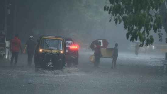
After a week of dormancy monsoon turned active to vigorous over the Northeast India due to the previous low pressure area which moved northward, instead of its usual track causing a mid latitude trough formation which joined the seasonal circulation over Northeast Assam. This trough caused  increase of southerlies & humidity over Northeast India causing heavy to extremely heavy rainfall there. Yesterday Mawsynram recorded 330 mm of extremely heavy rain in Meghalaya while nearby Sohra in Cherrapunji & Mawkyrwat recorded 243 & 228 mm of extremely heavy rain. In Arunachal Pradesh Wakro & Roing recorded 239 & 220 mm of extremely heavy rainfall while a cloudburst at Jibiram in Manipur caused 222 mm of extremely heavy rain including 155 mm rain fell in an hour. Assam & Tripura also recorded heavy rainfall. In Assam the rainfall were more in Northeast where Jiagaon recorded  160 mm of very heavy rainfall & In case of Tripura it was limited to South where Sabroom recorded 70 mm of heavy rainfall. In the upcoming days Isolated heavy to very heavy rainfall will continue to brush on the states of Northeast India. The spread & intensity will be more on the northern parts like usual, possessing minor flood & mudslide threat, damaging transport services. Conditions expected to improve in the southern parts like in the state of Mizoram & Tripura from this weekend while overall conditions will improve from the beginning of the next week from a brief time period. This week the Seven Sisters will see adverse weather conditions, people are requested to stay on high alert & put your distance from Riverside's or steep clif or unstable settlement & make sure to enough preparation . 

For getting more information about weather & related adverse weather conditions keep following Meteora Weather Service & prepare beforehand. 

Monsoon Arrives in the National Capital with the heaviest rain spell in 88 years! Adverse Weather likely on Saturday-Sunday -


Jun 28, 2024 -
As expected Monsoon made its one of the strongest approach over the Nation's capital - Delhi & NCR. A massive rainstorm at midnight caused fairly widespread heavy rainfall over Delhi with isolated extremely heavy rainfall marking the onset of Southwest Monsoon 2 days before the normal date. Out of 25 stations nearly 17 experienced heavy rainfall. The highest amount of rainfall recorded at Safdarjung Airport - clocking 228 mm & most of that occurred after mid night to morning. The rainfall at Safdarjung broke 88 years one day rainfall record, just after 235.5 mm rain on 28th June, 1935. Nearby lodi road of Indian Meteorological Department recorded 219 mm of extremely heavy rain. The Airport observatory also experienced heavy rainfall of 107 mm & all occurred in few hours. 

The rain storm caused roof collapse of Terminal 1 killing 1 person & injuring few people & damaging vehicles. Any operations in that section is suspended till further notice. This brief rainfall caused water logging across the National capital, disturbing the traffics & causing the normal day to day livelihood to be standstill in some areas. However rainfall conditions has improved from morning with overcast to mostly cloudy conditions. But the spell hasn't over fully as another spell expected in the weekdays. 

The reason for this type of intense rainstorm was because a cross trough position over North Delhi with there core positioned over Delhi. A north South trough was extending from the mid level circulation over Northeast Arabian sea to Delhi across another circulation over Rajasthan while another east west trough was extending from Delhi to the low pressure area over Bay of Bengal. This both trough were joined by a circulation over Delhi & Haryana extending up to the same level as others. Due to the influence of the low pressure area over Bay of Bengal good amount of Easterlies were entering up to Delhi at night while the north south trough helping humid winds from Arabian sea to reach near Delhi. This caused development of me so scale convective rainstorm development near Delhi, although the winds were not significant the rain was extreme. Usually this type of monsoon onset is seen over Western Coast or Northeast India, more on Mumbai. 

Conditions expected to deteriorate further from tomorrow onwards as a Westerly trough will also joined the above mentioned system while the low pressure area over Bay of Bengal will move northwest towards Delhi. Under its influence heavy rain expected on the weekdays, peaking on Sunday. Extremely heavy rainfall can also occur that day over the northern boundaries of Delhi, on Haryana. This type of conditions will again disrupt the transport service & the International Airport of Delhi. From next week the rainfall activities will decrease but intimate moderate rain shower with isolated intense showers will continue throughout the next week causing a pleasant weather with healthy environment as the air quality index will also come under good due to continuous rainfall activities

For getting more information about weather & related events follow us. 

Records in Decade! No Monsoonal Low forms in June after 2012, causing large deficiency in rainfall over India -

Jun 26, 2024 -

The country is facing a nearly opposite monsoonal scenario with the whole country rainfall amount till now is standing at -18.8 as of today, just near to be called deficit (-19% to 19% is considered as normal). Except Southern India every other regions of India facing rain deficit with the highest amount over Northwest India nearly -55%. Though monsoon expected to strengthen a bit but that won't make out the large deficiency the nation is standing currently. The arrival of the monsoon at the same time over Southern tip of India & Northeast India was pretty promising but after that it completely went in its dormant phase. 
The reason is surprising as founded by our experts. 

The reason behind the so called monsoon season & its rainfall is completely depends on the formation of monsoonal low mainly over Bay of Bengal. On average one monsoonal low forms each week of the monsoon as the monsoon trough comes over Bay head. But this year the northern limit of Monsoon is still lingering over the coast of East Medinipur of Gangetic West Bengal. The main driven force that helps the monsoon to reach deep in the country - Formation of a monsoonal low is absence this year & the last time it occurred was in 2012. As a result 2012 Southwest monsoon saw large deficiency across the nation except Northeast India. This year too except the Assam valley & Southern India other places recorded nearly no normal rainfall value. The reason behind the normal amounts of rainfall is presence of active east west trough & Arabian sea monsoon surge. But Bay of Bengal is completely calm with scattered clouds here & there. 

Other  secondary reasons were -
Western Disturbance -
In northern India absence of any significant western disturbance, prolonged heatwave made it more worse.

El Nino -
 The recent El Nino which reached near Super El Nino status made the country dry & warm with prolonged heatwave spell & lack of localized rainfall activities, mainly over Northwest & Central India. Although the ENSO value has turned down to neutral the aftermath remains for a month or two, especially during a powerful Nino phase.

Absence or presence of weak off shore trough - 
 Another main reason for Indian monsoon activities is presence of an off shore trough mainly over Western Coasts. Mumbai is used to get widespread tripple digit rainfall activities during the onset of of monsoon there. This year the onset was there occurred with cloud burst like events (Powai) too but the spread was in isolated areas. Its due to the weak & only brief presence of the monsoon trough & somali jet. 

MJO -
MJO which strengthens the monsoon cloud & helps to form monsoonal low were also absence throughout the month after cyclone remal

In conclusion this unfavorable conditions in the month of June will mark a significant stigma in the  monsoon performance & the economy over the country & its people. 

For getting more information about weather & related events stay tuned with us

Monsoon advanced over Southeast Rajasthan, likely to cover up Northern India in the coming days -


Jun 25, 2024 -
The performance of the Southwest monsoon remained nearly weak over India throughout the month. Till now the national rainfall deficit is at -18.3% from its normal value, barely falling under the normal category (-19 to 19 %). Moreover the prime regions of Monsoon in India like East & Northeast India are also having deficit of -16% with Assam & Meghalaya only saw above normal rainfall. Northwest & Central India witnessed deficit rainfall of -56% & -22%. In southern India conditions are still somewhat better with 10% surplus in rainfall activities then normal but the entire west coast remained deficit from normal. The main reason for it is absence of a monsoonal low from Bay of Bengal. Currently a Cyclonic circulation is over North central Bay of Bengal extending up to mid level, however that's also unlikely to organize & move east towards Eastern India during next 1-2 days joining with the east west trough across central India. Another broad circulation over Northeast Arabian sea & adjoining Southwest India & Southeast Pakistan also fueling the monsoon there as it covered the entire Kathiawar Peninsula, most parts of Gujarat & southeast parts of Rajasthan. In the coming days the monsoon is expected to advance further covering the remaining parts of Gujarat, Madhya Pradesh, Chhattisgarh, Jharkhand, Bihar & Uttar Pradesh, Uttarakhand, Himachal Pradesh, Jammu & Kashmir, Ladakh, Gilgit Baltistan, Azad Kashmir, Northern parts of Punjab & Haryana, making a big leap across the highlands of the central & eastern India & over the foothills of Himalaya. This spell will cause entire India covered under deep monsoon convective clouds with fairly widespread to widespread rainfall activities with isolated heavy to very heavy rainfall nearly all states of the country. Some isolated extremely heavy rainfall could also occur in the next 4-5 days over the foothills of Central Himalaya due to extra moisture incursion. While In the end of the month parts of Northwest India like Rajasthan, Harayana, Punjab, Western Madhya Pradesh, Uttarakhand, Himachal Pradesh & our Nation Capital Delhi may witness isolated heavy to very heavy rainfall marking the advancement of Southwest monsoon on time there. Thie wet spell of monsoon can actually revive the conditions back to life to the areas facing drought. In conclusion in the next few days monsoon expected to come back in its original form & make a big leap towards Northern India like the previous years. This type of spell could also cause water logging or flood issues in the urban areas like Northeast India or on the megacities but those would be negligible as conditions won't be too adverse. However preparation should be needed in the places like Western coast of India, Northeast India & Northwest India including Delhi in the upcoming days. This much needed rainfall would also help to revive the economy somewhat by improving the agricultural conditions across the country as the Industry sector of India is basically agricultural based

For getting more information on weather & related news timely & accurately stay tuned with us

Heavy Rains expected on the West Coast throughout the Week; Monsoon in active phase

Jun 25, 2024 -
Monsoon take a brief spell after an active spell. Even just 2 days prior Valpoi & Dodmarg recorded 259 & 215 mm of extremely heavy rainfall. But on 24th no places even recorded very heavy rainfall. Isolated heavy rainfall occurred throughout the Western coast from Kerala to Gujarat with the highest rainfall amount recorded in Harnai of 110 mn, except that Mani in Karnataka was able to touch the triple digit mark of 100 mm. Due to the previous monsoon surge the monsoon was able to touch up the southernmost parts of Kathiawar peninsula at Veraval. An off shore trough is responsible for this kind of coast long wet spell. A broad circulation extending up to mid level while horizontally covering Rajasthan, Gujarat, Maharashtra, Southeast Pakistan & Northeast Arabian sea. This feature along with a east west trough will cause extremely heavy rainfall over the plains of Gujarat while isolated heavy to very heavy rainfall will occur throughout the coast. Rest area will witness widespread rainshower activities with winds of 40-50 kph gusting to 60 kph. This activities likely to see reducement from the end of this month however it will boost the monsoon to cover up entire western coast by that time. People of Gujarat need to remain high alert till tomorrow from any kind of flooding rain

For getting more information on weather & related events timely & accurately follow us. 

Rainfall to reduce in Northeast India before peaking up again in month end -

Jun 24, 2024 -
After a brief spell of heavy rainfall in Northeast India rainfall going to reduce over Northeast India as the trough low which influenced heavy rainfall over the area has shifted southwards over Bay. The leftover circulation isn't able to do anything alone as the wind flow changed its direction due to the shift of the trough. Yet isolated very heavy rainfall occurred in Northeast Assam & adjoining Nagaland in the places like Moranhat near Dibrugarh & Mangkolemba near Mokokchung. Although there records are near the upper limit of heavy rainfall. Significant reducement expected on the next 3-4 days on the entire Northeast India as such the area could see a dry spell with isolated to scattered rainfall from localized monsoonal rainstorm. As a result temperatures will start to pick up & could reach near 37-38°C at some places like Guwahati recorded 36.5°C temperature yesterday. This on the other side will help to improve the damage caused by the minor flood recently. However rainfall going to increase again in the month end or particularly in the start of next month with isolated extremely heavy rainfall in some places of Assam valley causing the condition to deteriorate again. Temperature would also fall below 25°C but that's yet to watch as its too far. People should use this short time to organize everything. We'll keep monitoring over the situations for any change & let you know beforehand. 

For getting more information on weather & related events don't forget to follow us regularly! Have a safe & good day. 

Monsoon advanced over Eastern India, Further advancement likely over Northern India


Jun 22, 2024 -
After a brief stalling SW Monsoon finally made its onset over Eastern India. The responsible feature for it is the circulation which was over Sub Himalayan West Bengal & the trough it was connected. Both of them came down south a bit, but most importantly both became extremely broad. The first one covering entire Eastern India while the later circulation is still over Northeast India. Both of them tilted Southward & increased there vertical heights too, up to 7.6 km from MSL. this feature has the southern most limit from Chittagong in East to Vidarbh in West as another circulation over Rajasthan also moved south & all this are connected with a well marked trough. This feature led formation of intense thunderstorm activities yesterday over Eastern India forming thunderstorm, severe thunder squall etc. This feature caused isolated heavy rainfall with gale force winds of 65-70 kph in places like Baripada & Nowgong of Odisha & Madhya Pradesh. Nimpith in Gangetic West Bengal recorded 75 mm of heavy rainfall while in Odisha 108 mm of heavy rainfall recorded by Talcher. On 21st the Northern limit of the monsoon passes from Navsari in Gujarat to Raxaul in East through Jalgaon in Maharashtra, Mandla in Madhya Pradesh, Pendra Road in Chhattisgarh, Jharsuguda & Balasore in Odisha, Haldia in Gangetic West Bengal & Pakur & Sahebganj in Jharkhand. In the next few days the northern limit of the southwest monsoon will further approach in some more parts of Madhya Pradesh, Chhattisgarh, Jharkhand, Bihar, remaining parts of Gangetic West Bengal & Odisha & Gujarat & Parts of Eastern Uttar Pradesh in the next 3-4 days. Monsoon current is expected to go on an active to vigorous phase from the end of this month to the start of next month causing rampage over the foothills of Himalaya. Flood threat looms for the plains of Northern India & Northeast India & Bangladesh. With this the monsoon could catch up its normal line but that's yet to be watched. Stagnant phase of monsoon like this isn't too uncommon but rare. In the last 64 years it occurred only 8 times, with the year like 1960, 1974, 1976, 1997, 1998, 2003, 2009 & 2010 with 2009 saw a quite dramatic as due to Cyclone Aila the monsoon made its earliest arrival over Eastern India in half a century but also remained stagnant for 33 days, nearly a month making the most dormant break of monsoon in half a century. Coincidentally the monsoon made its onset over Kolkata on the same date like previous year, on the day of Summer solstice. The city & its adjoining Bangladesh district recorded isolated light to heavy rainfall with Shyambazar in Kolkata recorded 30 mm of moderate rainfall only. This sudden arrival also killed 3 people in Gangetic West Bengal from lightning as forecasted by us. How the monsoon will act from now is a thing to look for & as such we will keep you updated. 

For getting more information about weather & monsoon advancement follow us. 

Rainfall to increase over Western Coast of India. Monsoon to enter active phase -

Jun 19, 2024 -
Monsoon winds likely to set its wings over the entire west coast starting in the next 2-3 days lasting till the 1st half of July. Above average rainfall expected in this spell over many parts of the Western coast & adjoining area. The probable reason could be due to the arrival of MJO over the North Indian Ocean amplifying the monsoon surge causing off shore trough formation which will results up causing heavy rainfall. The spell would start from the southern parts like Karnataka & Kerala & then it would move northward up to Gujarat by the end of the month. Even parts of Southwest Rajasthan has a fair chance of receiving isolated heavy rainfall but that's yet too see as its too far away still. Isolated heavy rainfall already occurred in Konkan & Goa yesterday with Murmagao in Goa receiving 72 mm of heavy rain while Palghar in Maharashtra record 94 mm of rain. Except that Harnai & Dahanu also recorded 85 & 68 mm of heavy showers. Khambhalia in Gujarat recorded 233 mm of extremely heavy showers just 3 days ago & a similar situation is expected by the end of the month. Widespread rainstorm activities will cover up entire west coast with isolated very heavy rainfall at Malabar coast from the weekend. Isolated extremely heavy rainfall also possible over Kerala & South Interior Karnataka between Jun 23rd to 24th. From 25th the main interest of the activity will move northward towards northern Karnataka & adjoining Goa. By the end of the month the spell will reach Gujarat making onset of the Southwest Monsoon there while ending the prolonged heatwave spell over Northwest India. This spell would also cause isolated urban water logging & minor mudslide which could disrupt transport & communication, so we'll monitor the situation beforehand. 

For getting more news about weather & relevant updates stay tuned with us. 

Exceptionally Heavy Rains likely over Seven Sisters; Significant damage expected

Jun 17, 2024 -

The early arrival of Southwest monsoon over the Northeastern state has brought continuous heavy rainfall over the area. This conditions improved the rainfall deficiency over the seven sisters. The Assam valley along with Meghalaya had a deficiency of 55% while the rest area having deficiency of 45%. Conditions changed a bit after the arrival of monsoon as Assam reached just near the normal value while Meghalaya just didn't overcome its deficiency but it now has a excess amount of rainfall clocking at 31%. 

 A circulation over Northeast Assam & adjoining Arunachal Pradesh extending up to Mid level amplified by humid southerlies from the Bay of Bengal creating perfect conditions of development significant convective cell over Meghalaya. Yesterday Williamnagar in Meghalaya recorded extremely heavy rainfall of 225 mm. Lumding in Arunachal Pradesh also recorded 203.5 mm of heavy rainfall. Missed the mark of extremely heavy rainfall just by 1 mm. 12 places in Assam recorded heavy rainfall while 7 places recorded very heavy rainfall. The continuous rainfall improved the rainfall deficiency over Western Assam, Southern Meghalaya & hilly areas of Tripura. The main threat of the current spell will be focused on there. The Northern states of Seven sisters - Assam, Meghalaya & Arunachal Pradesh has chance to receive isolated extremely heavy showers even, particularly Meghalaya where exceptionally heavy rainfall could occur where rainfall value stands more than 500 mm. The peak of this activities will be on Jun 18th & conditions will improve after that although isolated heavy rainfall will still occur due to the topographic conditions of Northeast. 

Coincidentally Assam also saw a similar flood previous year around Jun 22nd to Jun 23rd. Similar conditions also expected this year. District like Bajali, Baksa, Barpeta, Biswanath, Chirang, Darrang, Dhemaji, Dhubri, Dibrugarh, Golaghat, Hojai, Kamrup, Kokrajhar, Lakhimpur, Nagaon, Nalbari, Sonitpur, Tamulpur, and Udalguri in Assam would be in threat due to rise in water level on various river like Diphu, Barak, Manas,Kopili etc. 

We advise everyone to keep your distance from the riverside & be careful when leaving near a steep gradient for avoiding being swept away from sudden flash floods, landslide or mudslide. The flood could also damage roads & disconnect many locality from nearby town. Further network disruption is also possible. Contamination in drinking water & outbreak of various disease from that could make ill or kill people further. To avoid that its better to move from the threat area or to get enough necessary food & water supply. The flood water could also ruin kutcha house or damage several house & those could be leave in that conditions for a longer time while some places may remain without connectivity for a longer time. This things cause further mental trauma for those who witness it. People also get lonely if they lost there family members or dearest people's. We will monitor the situation & let you know always before time in case. 

For getting more information about weather & flood stay tuned with us to get prepared yourself in advance

Know How & Why its important to check Weather before you chalk out your travel plans

Jun 16, 2024 -
Tourism is a fast growing industry and is expected to become one of the largest industries at world level. The people travel to outward destinations for different purposes, namely leisure and recreation, religious performance, sight seeing etc. The influence of weather and climate on recreation and tourism are weather & climate dependent. For example, visit to religious places doesn't have weather component as people having strong believes in there respective religion visit the places of worship braving the hostile & inclement weather conditions. Similarly, visit to cultural centers is also not guided by climatic factors rather strong faith & desire motivate the people to venture to undertake journey to the places of cultural importance irrespective of weather conditions. An example of how weather controls tourism is
Badrinath Dham and Kedarnath Dham located at higher elevations (10350 feet and 11750 Teet respectively) in the Himalayas are closed during winter season because of frost condition and snowfall. The roads have been constructed along the steep valley sides of the Alaknanda (For Badrinath) and the Mandakini(for Kedarnath) rivers. There are frequent road blocks during July-August because of landslides caused by cloudbursts and incessant monsoon rainfall. It is apparent that extremely low temperatures during winter season and early summer season (mid-November to mid-April) completely stop religious tours to four sacred
'dhams" (religious places of worships) e.g. Badrinath, Kedarnath. Gangotri and Yamunotri located in the Uttaranchal Himalaya, while rainfall and consequent landslides lessen the number of devotees during rainy season. It is also important to note that en-route weather is also significant for all sorts of tourists.

It may be mentioned that recreation, leisure and tourism industry depends upon correct information of pleasant, reliable and appropriate weather conditions en-route and at the sites and correct picture of political situation, social harmony and terrorism free environment. So, there is greater demand by the tourists for weather information about the selected sites. There are numerous sources of weather information as follows: (1) Telephone weather information services (TWIS), 2) weather brochures, (3) specialized publications. (4) holiday weather books, (5) television weather information services etc. It may be pointed that the agencies involved in the tourism industry present their weather brochures in such a manner at positive sides of the weather conditions are highlighted but negative points are deliberately omitted. The agencies want to sell out destinations with attractive advertisement highlighting the attractive aspects of the site ignoring unfavourable aspects. Pigram and Hobbs (1975) while commenting on such behaviour of tourism agencies have remarked, a significant portion of the budget for the tourist industry appears to be allocated to the 'image-makers for creating the desirable' weather picture. Advertising for tourism and immigration, in much of Australia, for example, often stress sun, surf and sand, perhaps fostering the impression that these are nationwide, year-round attributes' (J.E. Hobbs, 1980) but this is not true as this claim may be true only for a part of the year but the tourists, as impressed by the advertisement, get the impression that sunshine (sun), beaches (sand) and surfing (surf) are available for recreation and sports throughout the year.

It may be concluded that weather and climate have profound influence on the recreation and tourism industry. The weather conditions determine comfort of participants of sports and games and spectators and comfort in turn determines attendance of tourists which in turn determines the economy of the tourism industry.

To follow more news about weather & related news follow us regularly

Wait for Monsoon getting longer, Monsoon likely to make its advancement next week over East India!

Jun 15, 2024 - 
Its been 5 days since the Southwest monsoon made progress in any parts of the country. The Northern limit of the Southwest monsoon passes from Navsari in Gujarat to Islampur in Sub Himalayan West Bengal through passing states like Maharashtra, Telangana, Andhra Pradesh, Chhattisgarh & Odisha. Some parts of Southwest Bangladesh especially Khulna also remain out of the coverage of Northern limit of Monsoon. As a result this places witnessing mild to severe heatwave conditions. The last time monsoon advanced over the western coast of India was due to an active circulation over West Coast along a feeble trough. After that lack of any weather system made the monsoon stagnant. However the wait will be ending soon as the northern limit of Monsoon expected to make its advancement in the remaining parts of Telangana, Andhra Pradesh, Sub Himalayan West Bengal & some more parts of Maharashtra, Southern Odisha & Chhattisgarh, Gangetic West Bengal & Northeast Bihar around Jun 19th along with Kolkata. Surprisingly in the previous 2 years monsoon also made its advancement over Eastern India around the same time after a stagnant phase. During this spell states like Chhattisgarh, Southern parts of Jharkhand & Odisha could see isolated heavy rainfall while rest of Eastern India experience fairly widespread rainfall activities. This spell would be accompanied by mainly thunderstorm & as a result death due to lightning storms & water logging in urban areas is very much possible. We will closely monitor the situation. 

For getting more updates about weather & monsoon stay tuned with us. 

Polar Opposite Conditions occurred over May. Large excess in Southern India while Huge Deficient in Northern India -

Jun 15, 2024 -
May month passed with many records, breaking the longest heatwave spells in the northern parts of the country while record breaking rainfall occurred over Southern & Eastern parts of the country. Kolkata on the eastern parts of the country record 500 mm rainfall against the normal amount of 119 mm, 4 times then average while in west Alwar recorded 1.7 mm rainfall against the average value of 16 mm, nearly 10 times less than average. The reason can be found due to active monsoon currents over Southern India & Impact of Cyclone Remal over Eastern India & pre monsoon activities while even spawned a hurricane force Nor'wester over Bemetara in northern Chhattisgarh on May 11th causing winds to rise at 125 kph while giving heavy to very heavy rains over Odisha along with the capital city & cuttack around 129 mm crossing its average rainfall value of 106 mm in a single day. While in northern plains prolonged heatwave conditions with the lack of any weather system made the atmosphere absolutely dry killing nearly 200 people from it with Rajasthan alone taking toll of 133, nearly 65% of the total. Surprisingly Northeast India also remain rain deficient even after the impact of Cyclone Remal & following Assam flood. In the new month Jun conditions hasn't changed much but its deteriorating further due to the dormant monsoon activities. Rainfall activities going on Northeast India which could change the conditions a bit but that's also in modest, lack of any significant weather system making the monsoon weak. We will be closely monitoring for any kind of change in the situation & let you know beforehand. For that stay tuned with us. 

For getting any weather & climatological activities & news follow us regularly to remain on guard beforehand from everything. Thanks for reading & reaching us out. 

Back to Back Landslide killed 4 in Sikkim within 4 Days. Severe Weather Warning!

Jun 13, 2024 -

Conditions right now -
Heavy to extremely heavy rainfall triggering back to back deadly landslide activities across Southern parts of Sikkim. An active trough along the foothills of Eastern Himalaya along with the embedded circulation over Sub Himalayan West Bengal & with the support of continuous fresh Southerlies from Bay of Bengal decent convective firing occurring each day over Sub Himalayan West Bengal & Sikkim. This heavy rainfall activity caused back to back landslide killing 4 people in the last 4 days. The 1st landslide occurred on Jun 10th in the Western Sikkim. On the morning hours of Monday that landslide occurred over Majua village of Namchi killing 2 people instant while another women died later from it. 3 days after of that incident another landslide event occurred today near Mangan of Northern sikkim followed by an astonishing amount of extremely heavy rainfall there, clocking 220.1 mm. The massive landslide killed 1 person while 5 went missing. The landslide damaged several houses & roads there while sweeping away the electricity poles disrupting the transport & communication services, separating the damaged area. This accompanied with the continuous rainfall activities making the condition further worse by not giving the opportunity to revive the damage condition & relief workers to find who are missing or injured.  It affected the Mobile network of the Northern Sikkim too as a request to send an SDRF team to send ration at Mangan failed. The body of the dead person found in the Parkshep area of Mangan with 2 others missing from the same area, while 3 others went missing from Ambithang near Rangrang. Three house were also damage at Geythang while several other houses were damaged and road blocks at Nampthang near Pentok as per the official source. 

A house damaged due to landslides triggered by incessant rainfall, in North Sikkim, Thursday, June 13, 2024.

Damage -
Severe damage occurred at Sankalan on the Western Sikkim from the previous landslide where landslide shifted a police outpost to nearby location along with damaging the nearby bridge there. 

Damage over Sikkim due to the landslide caused one way traffic over the National Highway 10, the main lifeline of Sikkim to remain connect with the outer world. 

Forecast -

According to the weather conditions currently there there's no chance of decrease in rainfall activities rather the activities expected to increase in the upcoming days with threat concentrating over the Western Sikkim more. The Kanchenjunga range could even see large Avalanches due to this while remote area could see mudslide, lake outbursts deteriorating the conditions further. 

The district magistrate of Mangan district Hem Kumar Chettri convened an urgent meeting with all the heads of various department to  draw out a plan & overcome the situation

Relief Works -

An earthmover has been deployed near Mangshila college, south of Mangan to clear the debris from the National Highway from the landslide. 

The chief minister of Sikkim Prem Singh Tamang made a contact with the north district administration, police & officials of the other departments to ensure a swift & fast response to the devastation. Efforts are underway to provide every possible support to the victims, affected families including recovery assistant, temporary settlement & basic needs in the order of the CM of Sikkim. "The state government stands firmly with the victims of this unfortunate incident, pledging the utmost support to the bereaved families and all those affected and displaced by the landslides," he said.

Its advised to everyone don't go near riverside & be extra careful if anyone live nearby a steep gradient slope & heavy rain occurred there on that day or in the past several dayse, this conditions triggers landslide. Also stay connected with radio or mobile networks as much as possible as those could become lifesaver during emergency. 

To get more information about severe weather & relating event follow us & get yourself prepared from the upcoming threat ahead in time